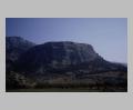
Priene.
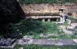
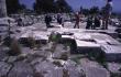
Wash basins in the Ephebeion in the gymnasium complex, Priene.
| Summary: | Grid-planned city at the foot of Mt. Mykale. |
| Type: | Fortified city |
| Region: | Ionia |
Periods:
Classical
Hellenistic
Roman
Byzantine
Physical:
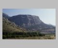
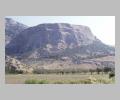
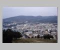
The city of Priene lies on the southern slopes of Mt. Mykale overlooking the Maeander river. The city largely excavated by the Germans in the late 19th century is planned on a strict grid, defying the steeply sloping topography of the site and imposing a rational human order on the landscape. Its well-preserved remains, with its temple of Athena, well-planned agora, theater, stadium, gymnasium, fortification walls and many excavated houses, form one of the best examples of a small Greek polis.
The city was laid out on a rectangular grid, with blocks measuring about 120 x 160 feet (35.40 x 47.20 m), a proportion of 3:4. These blocks were originally divided into 8 rather long and narrow houses, although later rebuilding has obscured much of the original scheme (see Westtorstrasse") is 5.55-5.60 m wide, about 19 Ionic feet; the street east of the Prytaneion 4.30 m (almost 15 feet), other streets average about 3.45 m wide, about 12 feet. Hoepfner and Schwandner restore an original scheme in which the north-south streets widen progressively towards the center of the city, from 12 feet at the gates to 16 and then 20 feet at the agora.
The impressive fortification walls also included the acropolis above the city. This was a relatively empty area, though, without much occupation other than defenses and barracks. The walls enclosed some 37 ha., of which the built-up lower city covered some 15 ha.
Description:
The remains of the city on Mt. Mykale are positively identified as Priene by inscriptions and coins. Practically no remains dating to earlier than the mid-fourth century were found at the site, however, despite its extensive excavation. The Germans concluded from this and from the layout of the city that Priene had moved to this site in the mid-fourth century from an earlier, yet undiscovered spot. They attributed the move to the silting of the Maeander river, which also engulfed Myus, Miletus and other nearby cities, as well, later, as Priene itself (
The end of the city is also problematic. Most of the houses seem to have been destroyed by fire in the second half of the second century BC, and never reoccupied. The bulk of the finds from the excavation come from this destruction level. Parts of the city, including many of the major public buildings, were occupied into the Roman period, though, and a Byzantine chapel attests occupation in that era.
Exploration:
The Society of Dilettanti sent three missions to Priene, in 1764-6, 1811-12 and 1868-9; excavations conducted during the last mission, by Richard Popplewell Pullan, uncovered the Temple and Temenos of Athena Polias. In 1895-1989 a German expedition led by Th. Wiegand and H. Schrader excavated much of the rest of the city, including the agora, further sanctuaries, and houses. Recent research by the German Archaeological Institute has refined their findings.
Sources Used:
Other Bibliography: