| Summary: | Grid planned city, capital of the Chalcidic League |
| Type: | Fortified city |
| Region: | Macedonia |
Periods:
Neolithic
Archaic
Classical
Physical:
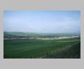
Olynthus is located between the westernmost and central "fingers" of the Chalcidic peninsula, about 2.5 km. inland from the sea. The country immediately surrounding the city is rolling fields, well drained and plentifully supplied with water. To the north, the Polygyros hills rise to some 3000 feet.
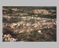
The city was built on two flat-topped hills rising about 30-40 m. above the surrounding plain (the North and South Hills). In addition, houses were built to the east of the two hills, down on the plain in the area known as the "Villa Section." A narrow ridge extending southwards from the southeast corner of the North Hill is known as the East Spur Hill (ESH). The South Hill was probably occupied as early as the seventh century, and continued to be densely inhabited throughout the life of the town. By contrast, the North Hill was not inhabited until the anoikismos of 432 or shortly thereafter (below).
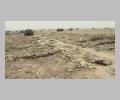
The western fortification wall was uncovered by the excavation in a number of places. The clearest stretch is along the west side of the North Hill, where it forms the back walls of the houses along the brow of the hill (cf.
A section of fortification wall was uncovered at the north end of the South Hill; but whether this wall is part of the enclosure that also ringed the North Hill or part of an earlier circuit that protected only the South Hill before the anoikismos is uncertain. The South Hill must have been fortified in both periods, however: Artabazus' siege of Olynthus in 479 BC shows that it was fortified at least that early (
The South Hill has an area of some 7 hectares. The North and East Spur Hills together measure some 17 ha., including the valley between the two hills. The extent of the Villa Section was not determined: roughly 16 ha. can be documented, but the section may continue considerably farther. The area documented by the excavations therefore totals about 40 ha., with the Villa Section a wild card. By contrast, the built-up area of the city of Priene, for instance, encompasses only some 15 ha., although the walls enclose about 37 ha. Of this area, about 4 ha. was actually excavated. This is a fairly small proportion of the whole town, but is more than almost any other Greek urban site.
The North Hill was laid out in an orthogonal plan which, with some irregularities, filled the entire area of the hill. Houses were mostly grouped in blocks of ten, comprised of two rows of five houses separated by a narrow alley. On the east side of the city, however, the blocks were shortened to allow the roads to follow the topography of the hill. The streets are oriented almost due north-south and east-west.
The north-south arteries were labelled "avenues" A, B, C etc. by the excavators, the east-west arteries "streets" i, ii, iii etc. Blocks were identified by the intersection of street and avenue at their southwest corner. Within the blocks, houses are numbered from the northwest: house A v 1 is at the northwest corner of block A v; A v 2 is at the southwest corner of A v; A v 3 is the second house from the west on the north half of A v, and so forth.
Towards the eastern part of the city the grid plan becomes more irregular. The plan of the Villa Section was not completely established; all the houses in the blocks were probably not built, but space was left open around some of the houses. The grid here on the plain is oriented 2-3 degrees nearer to magnetic north than the grid on the North Hill, and is probably a later extension.
Most of the houses of Olynthus conform to a basically similar ground plan, commonly referred to as a "pastas house." They are roughly square, averaging about 17.2 m. across. Two important axes cross the house from east to west: one near the midpoint of the house divides it into two nearly equal parts, the second divides the northern half into two portions. These axes govern the placement of walls and pillars, which had to be aligned to support the common roof which ran over the northern half of the entire row of houses.
Like most Greek houses, they are based around a central courtyard, often paved. The court was nearly always located on the southern half of the house (cf.
Most of the other rooms open directly onto either the court or the pastas. The organization of rooms in typical Olynthian houses is thus paratactic or non-hierarchical: that is, there are relatively few "back rooms" on the ground floor to which access is restricted by an intermediate room. Nor is there a single dominant room or axis, as there is in the "prostas" type of house, as well as in the typical Roman house.
A number of different room types are commonly found in Olynthian houses. A "kitchen complex" consisting of a large chamber, sometimes with a built hearth, and one or two smaller spaces partly divided from it on one side, is one such unit. One of the smaller rooms usually served as a bathroom, with bathtubs frequently found in situ. The other small room seems to have been used for cooking; in most cases these rooms could be entered from the court or pastas, and they often contained ashes and many artifacts.
Another distinctive suite of rooms is the andron-anteroom complex. Androns, or formal dining rooms, are well attested both in literary sources and archaeologically, not only at Olynthus but at many other sites (e.g.
A number of houses have special workrooms and shops, opening onto the street (e.g.
Within this very regular plan, however, there is considerable variation, and the apparent uniformity of the house plans is, on closer inspection, somewhat deceptive. Some houses devote a lot of space to androns, kitchens and other specialized rooms; others have more general-purpose spaces; others have many shops, and so forth. Moreover, the houses on one block tend to be more similar to one another than they are to houses on other blocks. Houses with many shops are mostly found along Avenue B, which probably formed a major commercial artery through the city. The houses of block A vi have more androns, more kitchens, and more decorated rooms than those of A v, while the north half of block A vii is much more irregularly planned than the south half. The coherence of house blocks may result from social ties among the households who built the block. The blocks thus form social as well as physical building units of the city. And the differing uses of space, equipment, and assemblages in houses in different parts of the city shows that the city was organized in different sorts of neighborhoods, and that households of different neighborhoods engaged in different trades and economies.
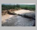
On the South Hill, two public areas were excavated. At the north tip of the hill was a rather poorly-preserved area with two "arsenals" or stoas and fragments of other large buildings. To the south of this area is the "Civic Center," consisting of a large building built of ashlars which may have been a bouleuterion or other meeting place.
Another public area is located towards the south end of the North Hill. This consists of an open plaza, about 85 m. wide and perhaps 130 m. long, which was apparently free of building. Three public buildings surround the north side and northeast corner of this plaza: a poorly preserved stoa-like building along the north side, a building with central colonnade at A iv 10 (so-called "bouleuterion"), and a fountain house at A iii 9. This open space was probably the agora of the city.
The fountain house in the northeast corner of the agora (building A iii 9) was fed by a large terracotta pressure pipe set some six meters below the surface at the bottom of a subterranean tunnel. The pipe continued northward beneath Avenue A, leaving the city through the gate at the northern end of the avenue. The pipe was apparently fed from sources in the hills to the north, some 12 km. away.
No sanctuaries have been found in the city; the main sanctuary of the city may have been outside the city walls.
Three cemeteries were partly explored by Robinson's team. Some 560 graves were excavated at the main one, known as the Riverside Cemetery, which was located just to the west of the city. To the north, the North Cemetery produced only some 30 graves, more widely scattered than at the Riverside Cemetery. The third burial ground was the East Cemetery, located on a small knoll some 700 m. east of the tip of the South Hill. In addition, a Macedonian-type chamber tomb was excavated some 2 km west of the city. Robinson believed that these three graveyards were the only ones used by the Olynthians.
Description:
The urban history of Olynthus can be divided into fairly distinct periods. There is an early phase, little known either historically or archaeologically; the rebellion from Athens of 432 BC and the anoikismos ("moving inland"), in which the populations of some of the neighboring Chalcidian cities moved inland to Olynthus to form a larger and more defensible city; the growth of Olynthus and of the Chalcidic state in the fourth century, and finally the destruction of the city by Philip of Macedon in 348 BC.
In the Neolithic period there was a small settlement on the South Hill. No Bronze Age remains are preserved on the site, but nearby Agios Mamas was inhabited during that era. Archaic occupation begins in about the seventh century, when a town was founded on the South Hill (
At some point this town was taken, according to Herodotus, by the Bottiaeans, a local tribe which had been driven here by the Macedonians (
In 432 BC, in the face of Athenian aggression, Perdiccas, the king of Macedon, persuaded a number of Chalcidic cities to move inland and form a single, fortified city at Olynthus (
At some time before 382, the Chalcidians formed a League with Olynthus as its capital (see
Olynthus was sacked and burned by Philip of Macedon in 348 BC, and this destruction is responsible for the unusually fine preservation of the houses and their contents (
A small area of the site at the north end of the North Hill was reoccupied after 348 BC: early Hellenistic coins were found in considerable numbers there, as well as in the public buildings which were apparently robbed by the late settlers. There has been some doubt about how complete the abandonment was in recent years, and it has been claimed that most of the site was reoccupied after Philip's destruction. This author's analysis of the coins and other data from the site, however, suggests that while a small area was undoubtedly reoccupied, the greater part of the site was definitively abandoned.
Exploration:
The site was excavated in four seasons between 1928 and 1939 by D.M. Robinson. Recent excavations and restorations are being undertaken by Dr. J. Vokotoulou.
Sources Used:
Hesp. 22-23 (1953-54)History of Olynthus (Johns Hopkins Studies in Archaeology 17, 1933)