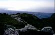
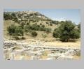
View Southwest towards the sea, Epirus, Kassope.
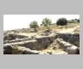
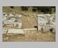
Interior view of the Katagogeion, Epirus, Kassope.
| Summary: | Important grid-planned city in Epirus. |
| Type: | Fortified city |
| Region: | Epirus |
Periods:
Hellenistic
Physical:
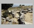
Kassope lies on a S plateau of Mt. Zalonga in Epirus, ca. 25 km N of modern Preveza and 8 km E of the coast. The city was laid out on the Hippodamian grid plan and had a circuit wall of ca. 3 km in length. The agora is in the SE quarter of the city and flanked by stoas on the N and E. A large theater is located in the NW part of the city and a bouleuterion, a prytaneion, and other public buildings have been identified.
Description:
Although there is some evidence of earlier occupation at the site, the city of Kassope was built in the Hellenistic period (possibly as a consolidation of smaller villages). The city apparently suffered only minor destruction in 167 B.C. in the period of the Roman conquest. It was probably abandoned in 30 B.C. with the founding of the city of Nikopolis to the S.
Exploration:
G. Miliadis conducted a trial excavation in 1926. S. Dakaris excavated between 1951 and 1955 and continued in 1977 with the collaboration of W. Hoepfner and L. Schwander of the German Archaeological Institute.
Sources Used:
Other Bibliography: