
| Summary: | A colony established by Corinth that grew to become an important city-state. |
| Type: | Fortified city |
| Region: | Ionian Islands |
Periods:
Archaic
Classical
Hellenistic
Roman
Physical:
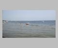
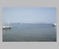
Corcyra, second largest of the Ionian Islands, is at the NW extreme of Greek territory, ca. 3 km W of the coast of Albania. It is a fertile and well-watered island and a natural stopover for sea traffic between Greece and Italy.
The ancient city of Corcyra (just S of the modern city) was established by Corinthian colonists on a large hook-shaped peninsula at the center of the sheltered E coast. The peninsula encloses a lagoon (the ancient Hyllaian Harbor) that could be closed by a chain. The fortified ancient city spanned the peninsula from the lagoon on the W to the bay of Garitsa (ancient Alkinoos, the 2nd port of Corcyra) on the E, and extended to the highland in the S, to the acropolis (at the present village of Analipsis).
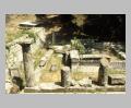
The Archaic Temple of Artemis sat on the lower N slopes of the acropolis hill. Other Archaic and Classical sanctuaries and remains have been located on the peninsula, but much of the ancient city has been quarried for stone to build the Medieval city and fortresses to the N.
Description:
The earliest known human occupation of the island dates to the Mesolithic period, but according to ancient authors the inhabitants were barbarians until Corinth established a colony there in 734 B.C. The colony was placed on the E coast of the island, where a small group of Euboean merchants had already founded a maritime way station.
Corcyra prospered and soon began to form colonies of its own; leading to a conflict with the mother city in 664 B.C. and the first recorded sea battle between Greek city-states. New conflicts between Corcyra and Corinth in 435-431 B.C. brought Athens to the aid of Corcyra and precipitated the Peloponnesian War. During the following 2 centuries the island's alliance passed from Athens to Sparta to Epirus.
Corcyra came under Roman control in 229 B.C. and served as a major naval base. The city was abandoned after destruction by the Goths in the 6th century A.D. and was used as a quarry for the later city to the N.
Exploration:
Early topographical research by Schliemann, Bérand, Dörpfeld and others. The first systematic excavations in 1910-1914 were directed by Versakis and Rhomaios for the Greek Service and Dörpfeld for the German Institute. This work, south of the modern town of Corfu was continued by Rhomias in 1919-1920; by Papademetriou in 1939; by V. Kallipolitis in 1954-1961; and since 1962 by G. Dontas. Explorations in the northern part of the island include those of W. Dörpfeld in 1911; V. Kallipolitis, 1957-1961; K. Kostoglou-Despini in 1971; and A. Sordinas in the early 1960's.
Sources Used:
Other Bibliography: